Cody's Map Catalog
Sunday, July 17, 2011
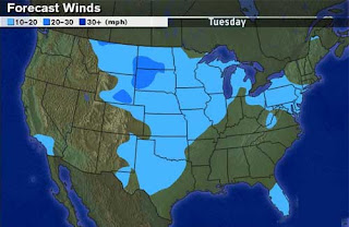
Isoline Map
http://www.kidsgeo.com/geography-for-kids/0034-isolines.php
Isoline maps are used for forecasting the weather. Everything between lines is assigned a certain value. The areas between the lines can be colored in like this map does. This map is showing wind speed across the United States.
No comments:
Post a Comment
Newer Post
Older Post
Home
Subscribe to:
Post Comments (Atom)
No comments:
Post a Comment